Advanced Surveying MCQs

Welcome to our comprehensive collection of Multiple Choice Questions (MCQs) on Advanced Surveying, a fundamental topic in the field of Civil Engineering. Whether you're preparing for competitive exams, honing your problem-solving skills, or simply looking to enhance your abilities in this field, our Advanced Surveying MCQs are designed to help you grasp the core concepts and excel in solving problems.

In this section, you'll find a wide range of Advanced Surveying mcq questions that explore various aspects of Advanced Surveying problems. Each MCQ is crafted to challenge your understanding of Advanced Surveying principles, enabling you to refine your problem-solving techniques. Whether you're a student aiming to ace Civil Engineering tests, a job seeker preparing for interviews, or someone simply interested in sharpening their skills, our Advanced Surveying MCQs are your pathway to success in mastering this essential Civil Engineering topic.

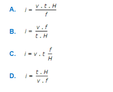
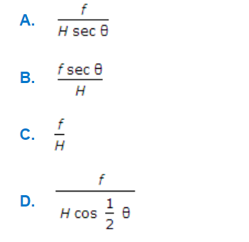
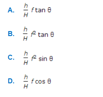
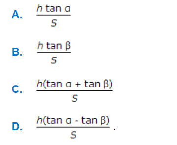
Note: Each of the following question comes with multiple answer choices. Select the most appropriate option and test your understanding of Advanced Surveying. You can click on an option to test your knowledge before viewing the solution for a MCQ. Happy learning!

So, are you ready to put your Advanced Surveying knowledge to the test? Let's get started with our carefully curated MCQs!

Advanced Surveying MCQs | Page 1 of 20

Q1.
The following parallax equation is applicable to entire overlap of the photographs only if parallax is measured
Discuss
Answer: (b).parallel to base line
Q2.
If α, H, A and δ be the altitude, hour angle, azimuth and declination of a circumpolar star at its elongation, in latitude λ, the following relation holds good

a.

A

b.

B

c.

C

d.

D

Discuss
Answer: (d).D
Q3.
The relation between the air base (B), photographic base (b), flying height (H) and the focal length (f) of a vertical photograph, is

a.

A

b.

B

c.

C

d.

D

Discuss
Answer: (a).A
Q4.
The scale of a vertical photograph of focal length f taken from height of H metres above M.S.L., at a point of reduced level h, is

a.

A

b.

B

c.

C

d.

D

Discuss
Answer: (c).C
Q5.
The correction applied to the measured base of length L is
Discuss
Answer: (d).All of these
Q6.
If v, t and f/H are the ground speed of the aircraft, the shutter speed of the camera and the scale of the photograph respectively, then the amount of image displacement

a.

A

b.

B

c.

C

d.

D

Discuss
Answer: (c).C
Q7.
The scale of a tilted photograph of focal length f taken from an altitude H, along the plate parallel through principal point is

a.

A

b.

B

c.

C

d.

D

Discuss
Answer: (a).A
Q8.
The maximum error in radial line assumption, is

a.

A

b.

B

c.

C

d.

D

Discuss
Answer: (a).A
Q9.
α and β are the angles subtended by a point of elevation h at their air station with respective plumb points. Photo scale and focal length of the lens being S and f respectively. Parallax displacement of the point due to relief, is

a.

A

b.

B

c.

C

d.

D

Discuss
Answer: (c).C
Q10.
The scale of a tilted photograph of focal length f, taken from an altitude H, along the plate parallel through plumb point, is

a.

A

b.

B

c.

C

d.

D

Discuss
Answer: (b).B
Page 1 of 20